


grouvelin

PatriceCocuaud
User
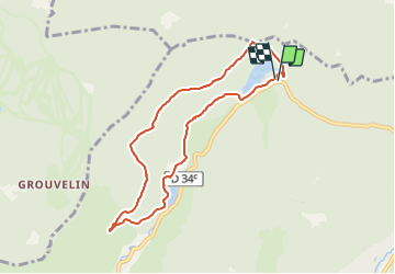

Length
7.4 km

Max alt
989 m

Uphill gradient
182 m
Km-Effort
9.8 km

Min alt
860 m

Downhill gradient
183 m
Boucle
Yes
Creation date :
2021-12-19 11:57:26.579
Updated on :
2021-12-19 13:06:30.214
1h08
Difficulty : Easy

FREE GPS app for hiking
 SityTrail
IGN / Geographical institutes
SityTrail Plus
The world is yours!
About
Trail Cross-country skiing of 7.4 km to be discovered at Grand Est, Vosges, La Bresse. This trail is proposed by PatriceCocuaud.
Positioning
Country:
France
Region :
Grand Est
Department/Province :
Vosges
Municipality :
La Bresse
Location:
Unknown
Start:(Dec)
Start:(UTM)
347017 ; 5324239 (32U) N.
Comments